Dr. Karen Herman, Executive Director, Sky Mountain Wild Horse Sanctuary
The 23,882-acre Jarita Mesa Wild Horse Territory (JMWHT) is located in rugged, forested mountain terrain in the Carson National Forest of New Mexico. Prior to passage of the Wild Free-Roaming Horses and Burros Act of 1971, wild horses in the territory were shot to reduce their numbers. Subsequently, between 1971 and 2012, the US Forest Service permitted the roundup and removal of wild horses for population control.
In the past, helicopter surveys were used to estimate the number of wild horses in the JMWHT herd. This estimate guided calculations of the number of wild horses to be removed to achieve the predetermined “appropriate management level” (AML). However, helicopter surveys were stressful for the horses, which fled in response to the sight and sounds of the machines. In addition, the density of trees on the JMWHT reduced the accuracy of such aerial surveys.
Using funds obtained through a Christine Stevens Wildlife Award, Sky Mountain Wild Horse Sanctuary and Dr. Allen Rutberg of Tufts University developed a methodology utilizing images from trail cameras, digital video and photographs, and on-the-ground observation to document the identity, location, and travel patterns of each band of wild horses and bachelor studs. These data, which continue to be collected, were used to construct a database with detailed descriptions of the composition of each band and the markings and identifying features of individual band members. In addition, a master map of the JMWHT showing band locations is in development.
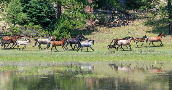
To date, 41 wild horses—mapped across eight locations within the JMWHT—have been identified and documented in phase I of the survey. These 41, representing an estimated 30–40 percent of the herd, include three bachelor studs and 38 members of six distinct family bands. Not surprisingly, access to water is the primary factor driving band locations and travel patterns, although the impact of the Bonita wildfire, which burned approximately 7,500 acres in the JMWHT during the survey effort, is currently under evaluation.
This research demonstrates that, in contrast to helicopter survey methods, utilizing low stress techniques to collect photographic data combined with on-the-ground observation is an effective and humane way to locate, identify, and document elusive wild horses in heavily forested terrain. Compared to helicopter surveys that rely on extrapolation to develop estimates of horse population numbers, this new methodology permits the development of highly detailed descriptions of individual horses, band composition, and location, resulting in a more accurate count of the total herd.
The survey methodology provides a model that can be used with other wild horse herds at a similar cost to traditional population survey methods using helicopter counts from the air. The true innovation of this survey methodology is how the data will be used to improve the application of immunocontraceptives, a minimally invasive management tool for wildlife population control, preserving the freedom of wild horses. The horse-specific descriptions, band composition, and location data improve both the efficiency of immunocontraceptive administration and the quality of the data used to measure the impacts of immunocontraception on the reproduction of individual horses, bands, and the whole population.